The Stanford School of Earth, Energy & Environmental Sciences is now part of the Stanford Doerr School of Sustainability.
This page is currently being maintained for archival purposes only. For the latest information, please visit us here.
Is climate change behind California's current drought?
Stanford scientists are using measurements and computer simulations to investigate the worst drought in California's history.
By
Ker Than
February 25, 2014
John Todd

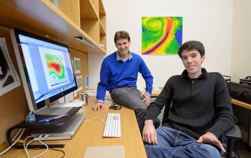
<p>Noah Diffenbaugh and Daniel Swain</p>
California's parched landscapes are receiving a much-needed soaking this week as heavy rainstorms roll across the west coast. The break in the state's dry spell is due to a weakening of an atmospheric anomaly that has been hovering above the northern Pacific Ocean. Dubbed the "ridiculously resilient ridge" by a Stanford graduate student, this enormous region of atmospheric high pressure has been squatting off the coast of western Canada since January 2013, diverting storms northward, away from California and toward Alaska.
In recent weeks, however, this blocking ridge has begun dissipating enough to allow a highly concentrated "atmospheric river" of moisture originating near Hawaii – nicknamed the "pineapple express" – to break through and soak northern California in early February, and for a new round of storms to penetrate the state this week.
But the much-needed downpour won't be nearly enough to end the state's current drought, which is the worst in its recorded history.
"It's the driest period in San Francisco since at least the Gold Rush," said Daniel Swain, a graduate student in the lab of Noah Diffenbaugh, an associate professor of environmental Earth system science at Stanford. "At this point, we would need at least 10 fairly big storms to achieve normal precipitation levels. But if we were to actually get that much rainfall between now and late March, it would likely result in flooding."
Average annual precipitation levels vary widely across the Bay Area, from 15 inches in San Jose to more than 50 inches in parts of the Santa Cruz Mountains. But the key point, Swain said, is that in every locale, the amount of rainfall is well below 50 percent of average for this point in the 2013-2014 water year.
There are also signs that the recent waning of the ridiculously resilient ridge – or "Triple R" for short – is temporary. "While it's certainly not as strong right now as it was in January, there are signs that it may be strengthening during the second half of February," said Swain, a life-long resident of Northern California who has an undergraduate degree in atmospheric science from UC Davis.
The dreaded Triple R
Swain said he coined the term "ridiculously resilient ridge" to highlight the unusually persistent nature of the offshore blocking ridge. He first used it last fall in a posting on his blog, the California Weather Blog. It was quickly picked up by the popular media.
Blocking ridges frequently form in the atmosphere and can span thousands of miles, but they typically break up after a month or two. The Triple R, however, has persisted for more than a year, and the longer it hangs around, the less likely it is to break up. "It's a self-reinforcing process," Swain said. "Once it's been there for a long time, it rearranges the temperature distribution in the atmosphere and that reinforces the fact that the jetstream wants to move in a northern direction."
To understand how blocking ridges can cause drought conditions in California, Swain said to imagine a boulder that has fallen into a flowing stream. "The stream has two options, it can flow to one side of the boulder or the other," Swain said.
Similarly, blocking ridges are obstacles that divert the flow of the atmospheric wind current known as the jet stream. Storms that form in the Pacific are carried along the currents of the jet stream as it travels from west to east. However, the Triple R has caused the jet stream to flow almost exclusively to the north this winter. This means that the storms that California and other Western states rely on for the vast majority of their precipitation have instead been shifted north, where they have caused record levels of rain and snowfall in Alaska in recent months.
Drought of a different nature
The current drought is different from many of California's previous droughts. For example, the state's last major dry spell occurred in the early 1990s and was characterized by below-average amounts of rain and snowfall for several years.
"That's what we typically think of when we think of drought – a few years when precipitation is below normal. We don't conceptualize that the precipitation would just shut off," Swain said. "That's what's so remarkable about this drought. It's not a multi-year drought that's getting progressively worse as the years go by. It's that it has barely rained at all this year. That's a much more acute situation in a lot of ways."
While scientists understand how the blocking ridge is causing drought conditions, why it is so persistent is less clear. Swain and Diffenbaugh are investigating the extent to which climate change has influenced the formation of the ridge and whether continued global warming will make extreme droughts such as the one California is currently undergoing more likely. The pair is combining data from a variety of sources, including real-world measurements of temperature, rain, snowfall and atmospheric circulation, with computer simulations of the climate.
"It would be great if we could put the climate system in a lab and manipulate it in a controlled way. Unfortunately, we can't do that with the entire planet Earth," said Diffenbaugh, who is also a senior fellow at the Stanford Woods Institute for the Environment and a lead author for Working Group II of the Intergovernmental Panel on Climate Change (IPCC).
"What we can do with the models is simulate the climate that we have now, and also simulate the climate from the preindustrial era to remove the influence of humans from the atmosphere," Diffenbaugh said. "We can compare these two experiments in a controlled way using objective statistical methods to ask whether the likelihood of a drought like what California is experiencing now is the same or different between the current climate and the climate prior to global warming."
Rare but troubling
Diffenbaugh stressed that the Triple R conditions are extremely rare in historical experience, so it is possible that they have arisen in the atmosphere by chance. However, if climate change is contributing to the current drought, it would be consistent with other recent findings which suggest that global warming is increasing the risk of many kinds of extreme events.
In studies published in 2013, Diffenbaugh and his colleagues found that the global warming that has already occurred has increased the odds of record heat in the Midwest and Northeast four-fold and that continued climate change is likely to cause a robust increase in the conditions that lead to severe thunderstorms across much of the country over the next century.
"Whether or not this particular drought turns out to be influenced by global warming," Diffenbaugh said, "we do know that global warming is occurring and that it is increasing the risk of many kinds of extreme events. Understanding the causes of extreme events such as the current drought can provide very valuable insights for real-world decisions about how we manage our water and other climate resources and how we build resilience to climate-related disasters."
Ker Than is the associate director of communications for the School of Earth Sciences.
Image shows Noah Diffenbaugh (left) and Daniel Swain. Credit: John Todd


