| IN THIS SECTION:
|
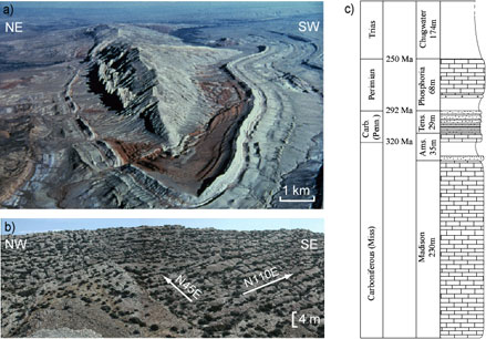
Mathematical Modeling of the Dynamics of Multi-scale Phenomena During Folding and Fracturing of Sedimentary RocksProject DescriptionFor over a century structural geologists have worked to elucidate the mechanisms of folding of sedimentary strata (Gilpin, 1883; Cloos, 1936; Ramberg, 1961; Stearns, 1969; Johnson, 1977; Davis, 1979; Treagus, 1981; Suppe, 1983; Dunne, 1986; Ramsay and Huber, 1987; Suppe and Medwedeff, 1990; Johnson and Fletcher, 1994; Bobillo-Ares, 2000; Strayer, 2002). This effort is motivated, in part, by the conviction that understanding the mechanisms responsible for folding will lead to important insights about the origin of tectonic forces and the nature of physical processes that shape Earth’s crust. Additional motivation comes from the ornate patterns of folds on maps and in outcrop that stimulate the geologist’s scientific curiosity (Fig. 1a). We propose to develop innovative methods for the characterization of folds using geological field data and differential geometry, and for the structural interpretation of folds and the development of fractures within folded strata (Fig. 1b) using continuum, fracture, and damage mechanics principles constrained by high resolution GPS and LiDAR field data.
Figure 1: Sheep Mounting Anticline, Bighorn Basin, Wyoming. a) Aerial photograph looking SE (Steve Mabee, MA State Geologist). b) Outcrop photograph of bedding surface of Tensleep sandstone with 2 fracture sets. c) Local stratigraphic section of units within the exposed anticline. Understanding folding and fracturing is critical to the planning and management of practical activities that have a significant impact on the nation’s economy and the well-being of its citizens. Folds are common traps for fluids in the subsurface, and fractures in both hydrocarbon reservoirs and groundwater aquifers are known to form important conduits for fluid flow (Shirley, 1987; National Research Council, 1996; Coward et al., 1998; Jones et al., 1998; Haneberg et al., 1999). Fractures not only help to charge folds with fluids (Aydin, 2000), they can rupture the seal and destroy the trapping potential (Smith, 1966; Jones et al., 1998). Both the propagation and aperture of opening fractures relate to their effectiveness as fluid conduits (Bai et al., 2000b; Bai and Pollard, 2001; Olson, 2003). In the environmental arena folds are being evaluated as potential reservoirs for excess CO2 storage (Rudnicki and Wawersik, 1999). Furthermore, inclined normal and blind thrust faults commonly are associated with folds that grow in amplitude as underlying faults slip (Suppe, 1983; Stein and Barrientos, 1985; Stein and Yeats, 1989; Rudnicki and Wawersik, 1999; Rivero et al., 2000; Carena and Suppe, 2002), so the mitigation of earthquake hazards requires a better understanding of the folding process.
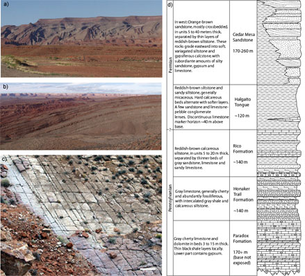
Figure 2: Raplee Ridge Monocline, Monument Upward, Utah. a) Photograph looking NE at western flank. Vertical relief of Raplee Ridge is ~500 m. b) Photograph looking N along the hinge. c) Outcrop photograph of limestone bedding surface from the Rico Fm. with two fracture sets. d) Local stratigraphic section of units exposed within the monocline. Although much progress has been made to understand how small-scale fractures (joints) develop during folding, we are not in a position to predict their location, orientation or spatial density from the large-scale geometry of folded strata. Fractures initiate and propagate as a result of stress concentrations at flaws and fracture tips (Griffith, 1921, 1924; Lawn and Wilshaw, 1975; Pollard and Aydin, 1988; Anderson, 1995) hence understanding the stress distribution in deforming strata in space and time is a prerequisite for predicting fractures. Stresses that arise in strata during fold development are unlikely to be explained by one folding mechanism (Gutierrez-Alonso and Gross, 1999). For example, strata that are domed by an expanding magma chamber experience considerable stretching, which is not included in bending models (Jackson and Pollard, 1988). The interaction between deforming layers with different constitutive properties is known to effect the local stress field (Treagus, 1988; Bai and Pollard, 2000; Bai et al., 2000a; McConaughy and Engelder, 2001; Bourne, 2003), as does the interfacial conditions of the layer boundaries (Cooke et al., 2000; Johnson and Johnson, 2000; Cooke and Underwood, 2001). The stress distribution changes over time as the fold evolves and the bedding rotates (Fischer and Wilkerson, 2000; Engelder and Peacock, 2001), and early formed opening fractures may rotate and be reactivated in shear (Cruikshank et al., 1991; Cruikshank and Aydin, 1995; Wilkins, 2001). Given these complexities it is no wonder that progress has been slow in developing predictive models of fractures in folds.
On the other hand, the recent past has seen exceptional advances in various technologies that record spatial data on geologic surfaces. The Global Positioning System (GPS), 3D seismic reflection surveys (Bergbauer et al., 2001; Bergbauer et al., 2003), digital elevation models (DEM) (Banerjee and Mitra, 2003), satellite and aerial photography, and Light Detection and Ranging (LiDAR) can provide vast spatial data sets of ever increasing resolution. These data present powerful new visual perspectives and unprecedented modeling opportunities (Shaw et al., 1999; Kattenhorn and Pollard, 2001; Maerten and Pollard, 2001; Haugerud et al., 2003). Along with improvement in data collection has come a new appreciation among geologists for the mathematics to describe geological structures (Bergbauer, 2002; Bergbauer and Pollard, 2003; Pollard and Bergbauer, in press) and advances in the statistics to analyze these data (Mallet, 1989; Mallet, 2002). Of particular interest here are differential geometry which uses the concepts of vector calculus to examine the local and global properties of curves and surfaces in 3D (Stoker, 1969) and geostatistics which combines the predictive and descriptive power of standard statistics with the spatial aspects of data used in the Earth Sciences (Isaaks and Srivastava, 1989). We propose to acquire new high resolution data sets using mapping-grade GPS receivers and helicopter-based LiDAR to constrain geometric models of folded strata. The combination of mathematical and statistical tools and the more precise data creates an unprecedented opportunity to build and analyze 3D models of geologic surfaces.
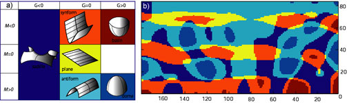
Figure 4: Shape curvature analysis. a) Classification of local shape to second order based upon mean, M, and Gaussian, G, curvature. b) Shape curvature for patch of McKim limestone (Fig. 3b). Given new geologic data sets and the means to create more precise models of kilometer-scale folded surfaces one could hope for an empirical approach that simply correlated the modeled surface shape with observed meter-scale fracture orientation or spatial density to provide a compelling predictive tool. However, the variety of physical properties, loading conditions, and sequences of tectonic events involved in the fold-fracture relationship suggests that deeper understanding of the physical process is required. Taking this point of view we propose to develop mathematical models based upon continuum, fracture, and damage mechanics to understand the relationships among the shapes of the folded surfaces, the internal states of stress, and the development of fractures. This is a challenging task that would have been unthinkable in the past, but developments in computational mechanics and computer resources encourage us to work collaboratively in this direction. |